Instrument – Chapter 10 – IFR En Route
Quiz Summary
0 of 61 questions completed
Questions:
Information
You have already completed the quiz before. Hence you can not start it again.
Quiz is loading…
You must sign in or sign up to start the quiz.
You must first complete the following:
Results
Results
0 of 61 questions answered correctly
Your time:
Time has elapsed
You have reached 0 of 0 point(s), (0)
Earned Point(s): 0 of 0, (0)
0 Essay(s) Pending (Possible Point(s): 0)
Categories
- Not categorized 0%
- 1
- 2
- 3
- 4
- 5
- 6
- 7
- 8
- 9
- 10
- 11
- 12
- 13
- 14
- 15
- 16
- 17
- 18
- 19
- 20
- 21
- 22
- 23
- 24
- 25
- 26
- 27
- 28
- 29
- 30
- 31
- 32
- 33
- 34
- 35
- 36
- 37
- 38
- 39
- 40
- 41
- 42
- 43
- 44
- 45
- 46
- 47
- 48
- 49
- 50
- 51
- 52
- 53
- 54
- 55
- 56
- 57
- 58
- 59
- 60
- 61
- Current
- Review
- Answered
- Incorrect
-
Question 1 of 61
1. Question
What is the definition of MEA?
CorrectIncorrect -
Question 2 of 61
2. Question
The lowest published altitude which meets obstacle clearance requirements and assures acceptable navigational signal coverage is the
CorrectIncorrect -
Question 3 of 61
3. Question
Reception of signals from an off-airway radio facility may be inadequate to identify the fix at the designated MEA. In this case, which altitude is designated for the fix?
CorrectIncorrect -
Question 4 of 61
4. Question
Reception of signals from a radio facility, located off the airway being flown, may be inadequate at the designated MEA to identify the fix. In this case, which altitude is designated for the fix?
CorrectIncorrect -
Question 5 of 61
5. Question
ATC may assign the MOCA when certain special conditions exist, and when within
CorrectIncorrect -
Question 6 of 61
6. Question
Acceptable navigational signal coverage at the MOCA is assured for a distance from the VOR of only
CorrectIncorrect -
Question 7 of 61
7. Question
Military training routes (MTR) above 1,500 feet are depicted on
CorrectIncorrect -
Question 8 of 61
8. Question
The altitude that provides acceptable navigational signal coverage for the route, and meets obstacle clearance requirements is the minimum:
CorrectIncorrect -
Question 9 of 61
9. Question
Which condition is guaranteed for all of the following altitude limits: MAA, MCA, MRA, MOCA, and MEA? (Non-mountainous area.)
CorrectIncorrect -
Question 10 of 61
10. Question
If no MCA is specified, what is the lowest altitude for crossing a radio fix, beyond which a higher minimum applies?
CorrectIncorrect -
Question 11 of 61
11. Question
In the case of operations over an area designated as a mountainous area, no person may operate an aircraft under IFR below 2,000 feet above the highest obstacle within a horizontal distance of
CorrectIncorrect -
Question 12 of 61
12. Question
In the case of operations over an area designated as a mountainous area where no other minimum altitude is prescribed, no person may operate an aircraft under IFR below an altitude of
CorrectIncorrect -
Question 13 of 61
13. Question
MEA is an altitude that assures
CorrectIncorrect -
Question 14 of 61
14. Question
Unless otherwise specified on the chart, the minimum en route altitude along a jet route is
CorrectIncorrect -
Question 15 of 61
15. Question
Under which of the following circumstances will ATC issue a VFR restriction to an IFR flight?
CorrectIncorrect -
Question 16 of 61
16. Question
What altitude may a pilot on an IFR flight plan select upon receiving a VFR-on-Top clearance?
CorrectIncorrect -
Question 17 of 61
17. Question
Which rules apply to the pilot in command when operating on a VFR-on-Top clearance?
CorrectIncorrect -
Question 18 of 61
18. Question
Which ATC clearance should instrument-rated pilots request in order to climb through a cloud layer or an area of reduced visibility and then continue the flight VFR?
CorrectIncorrect -
Question 19 of 61
19. Question
When can a VFR-on-Top clearance be assigned by ATC?
CorrectIncorrect -
Question 20 of 61
20. Question
When must a pilot fly at a cardinal altitude plus 500 feet on an IFR flight plan?
CorrectIncorrect -
Question 21 of 61
21. Question
Where are VFR-on-Top operations prohibited?
CorrectIncorrect -
Question 22 of 61
22. Question
What minimums must be considered in selecting an altitude when operating with a VFR-on-Top clearance?
CorrectIncorrect -
Question 23 of 61
23. Question
When operating under IFR with a VFR-On-Top clearance, what altitude should be maintained?
CorrectIncorrect -
Question 24 of 61
24. Question
In which airspace is VFR-on-Top operation prohibited?
CorrectIncorrect -
Question 25 of 61
25. Question
What reports are required of a flight operating on an IFR clearance specifying VFR on Top in a nonradar environment?
CorrectIncorrect -
Question 26 of 61
26. Question
When on a VFR-on-Top clearance, the cruising altitude is based on
CorrectIncorrect -
Question 27 of 61
27. Question
You have filed an IFR flight plan with a VFR on-Top clearance in lieu of an assigned altitude. If you receive this clearance and fly a course of
180°, at what altitude should you fly? (Assume VFR
conditions.)CorrectIncorrect -
Question 28 of 61
28. Question
What cruising altitude is appropriate for VFR on Top on a westbound flight below 18,000 feet?
CorrectIncorrect -
Question 29 of 61
29. Question
If, while in Class E airspace, a clearance is received to “maintain VFR conditions on top,” the pilot should maintain a VFR cruising altitude based on the direction of the
CorrectIncorrect -
Question 30 of 61
30. Question
You are flying on an IFR flight plan at 5,500 feet with a VFR-on-top clearance when you encounter icing. You know there is clear air above and you request 9,500 feet from ATC. They deny the request, but give you 7,500 feet. Are you still VFR-on-top?
CorrectIncorrect -
Question 31 of 61
31. Question
You encounter structural icing on an IFR flight plan at 7,000 feet. Your request for 9,000 feet is rejected by ATC. You request VFR-on-top at 7,500 feet, which is granted. What must you do with your IFR flight plan?
CorrectIncorrect -
Question 32 of 61
32. Question
ATC has approved your request for VFR-on-top while on an IFR clearance. Therefore, you
CorrectIncorrect -
Question 33 of 61
33. Question
Refer to figure 89 below. What type airspace exists above Bryce Canyon Airport from the surface to 1,200 feet AGL?
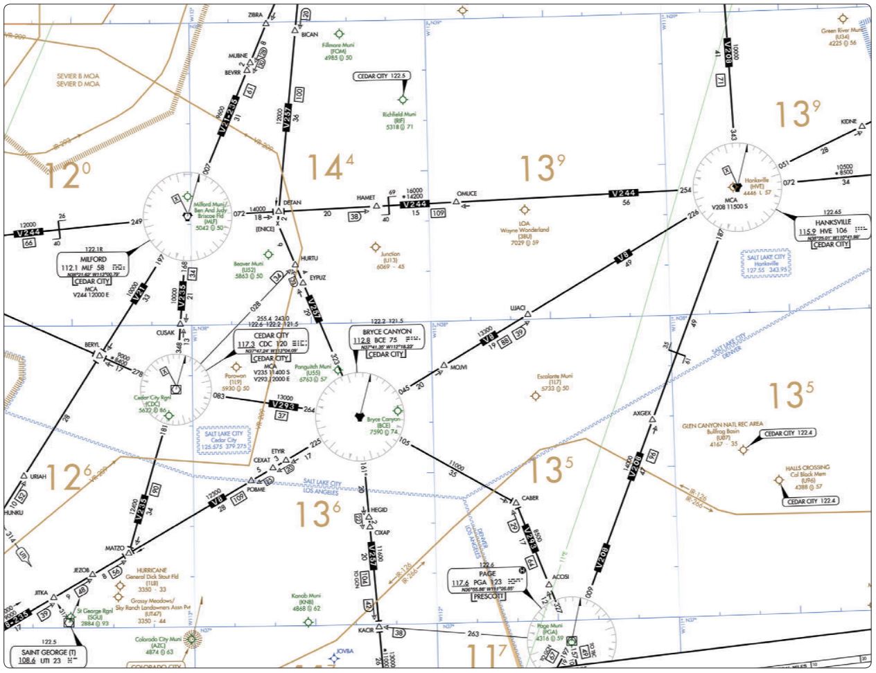 CorrectIncorrect
 -
Question 34 of 61
34. Question
Refer to figure 90 and figure 89 below. What is your relationship to the airway while en route from BCE VORTAC to HVE VORTAC on VB?
 CorrectIncorrect
 -
Question 35 of 61
35. Question
Refer to figure 91 below. What are the two limiting cruising altitudes usable on V343 for a VFR-on-Top flight from DBS VORTAC to RANEY intersection?
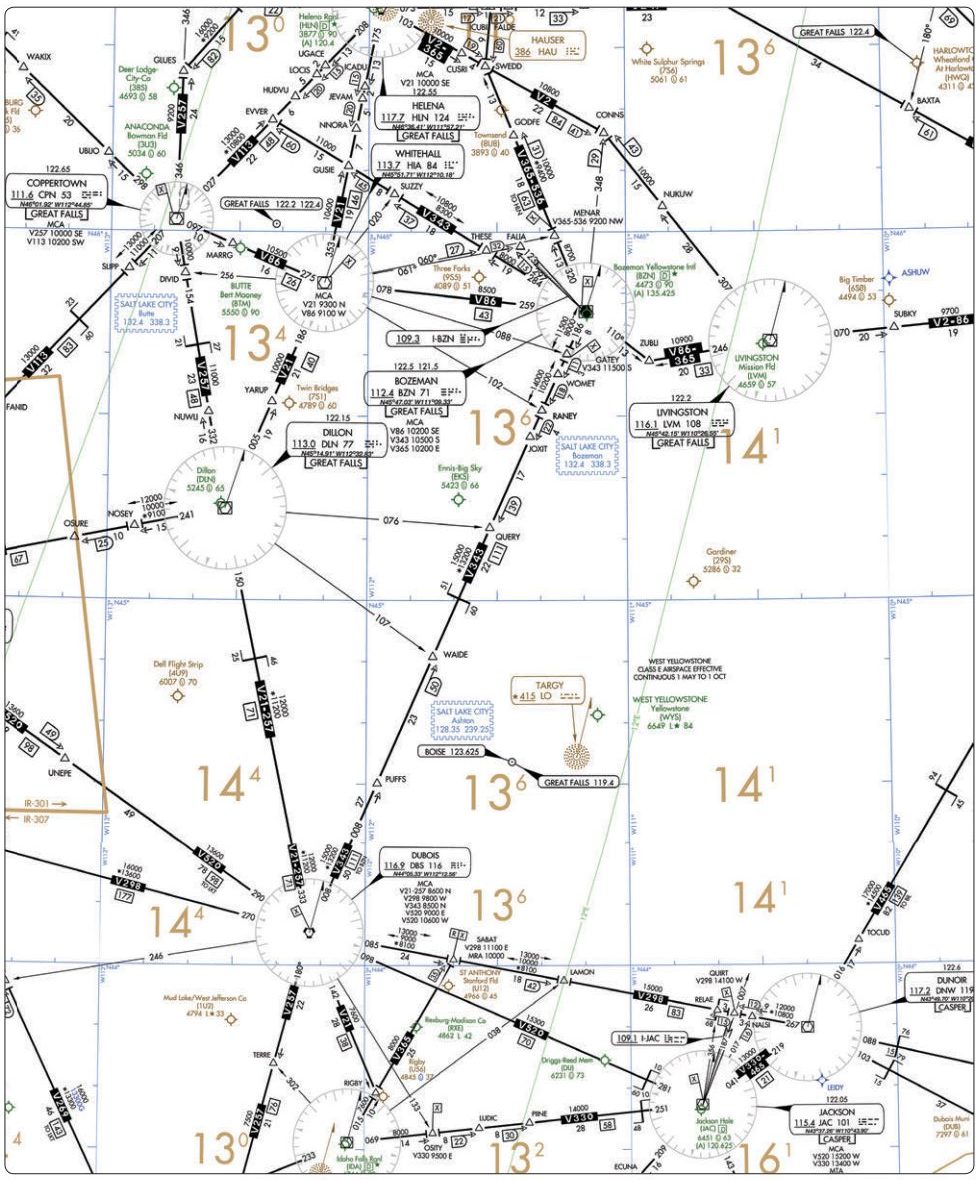 CorrectIncorrect
 -
Question 36 of 61
36. Question
Refer to figure 91 below. What should be the approximate elapsed time from BZN VOR to DBS VORTAC, if the wind is 24 knots from 260° and your intended TAS is 185 knots? (VAR 17°E.)
CorrectIncorrect -
Question 37 of 61
37. Question
Refer to figure 91 below. Southbound on V257, at what time should you arrive at DBS VORTAC if you crossed over CPN VORTAC at 0850 and over DIVID intersection at 0854?
CorrectIncorrect -
Question 38 of 61
38. Question
Refer to figure 91 below. When flying a northbound IFR flight on V257, what is the minimum crossing altitude at DBS VORTAC?
CorrectIncorrect -
Question 39 of 61
39. Question
Refer to figure 91 below. What are the oxygen requirements for an IFR flight eastbound on V520 from DBS VORTAC in an unpressurized aircraft at the MEA?
CorrectIncorrect -
Question 40 of 61
40. Question
Refer to figure 91 below. Where should you change VOR frequencies when en route from DBS VORTAC to JAC VOR/DME on V520?
CorrectIncorrect -
Question 41 of 61
41. Question
Refer to figure 91 below. What lighting is indicated on the chart for Jackson Hole Airport?
CorrectIncorrect -
Question 42 of 61
42. Question
Refer to figure 91 below. What is the minimum crossing altitude at SABAT intersection when eastbound from DBS VORTAC on V298?
CorrectIncorrect -
Question 43 of 61
43. Question
Refer to figure 91 and legend 33 below. What is the function of the Great Falls RCO (Yellowstone vicinity)?
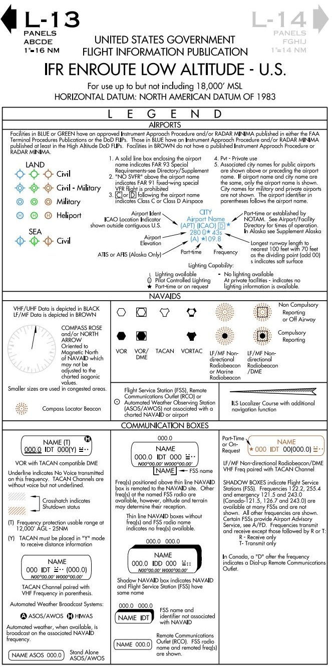 CorrectIncorrect
 -
Question 44 of 61
44. Question
In the event of two-way radio communications failure while operating on an IFR clearance in VFR conditions, the pilot should continue
CorrectIncorrect -
Question 45 of 61
45. Question
Refer to figure 193 below. On which frequencies could you communicate with the Montgomery County FSS while on the ground at College Station?
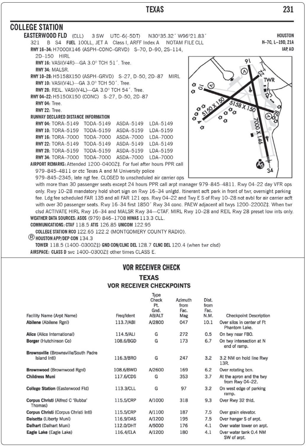 CorrectIncorrect
 -
Question 46 of 61
46. Question
Refer to figure 193 below. Which indications on the VOR receivers and DME at the Easterwood Field VOR receiver checkpoint would meet the regulatory requirement for this flight?
CorrectIncorrect -
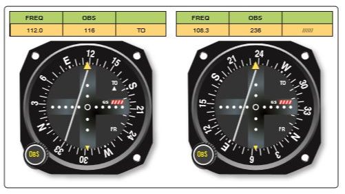
Question 47 of 61
47. Question
Refer to figure 64 below. The course deviation indicator (CDI) is centered. Which indicators on the No. 1 and No. 2 VOR receivers over the Lafayette Regional Airport would meet the requirements for the VOR receiver check?
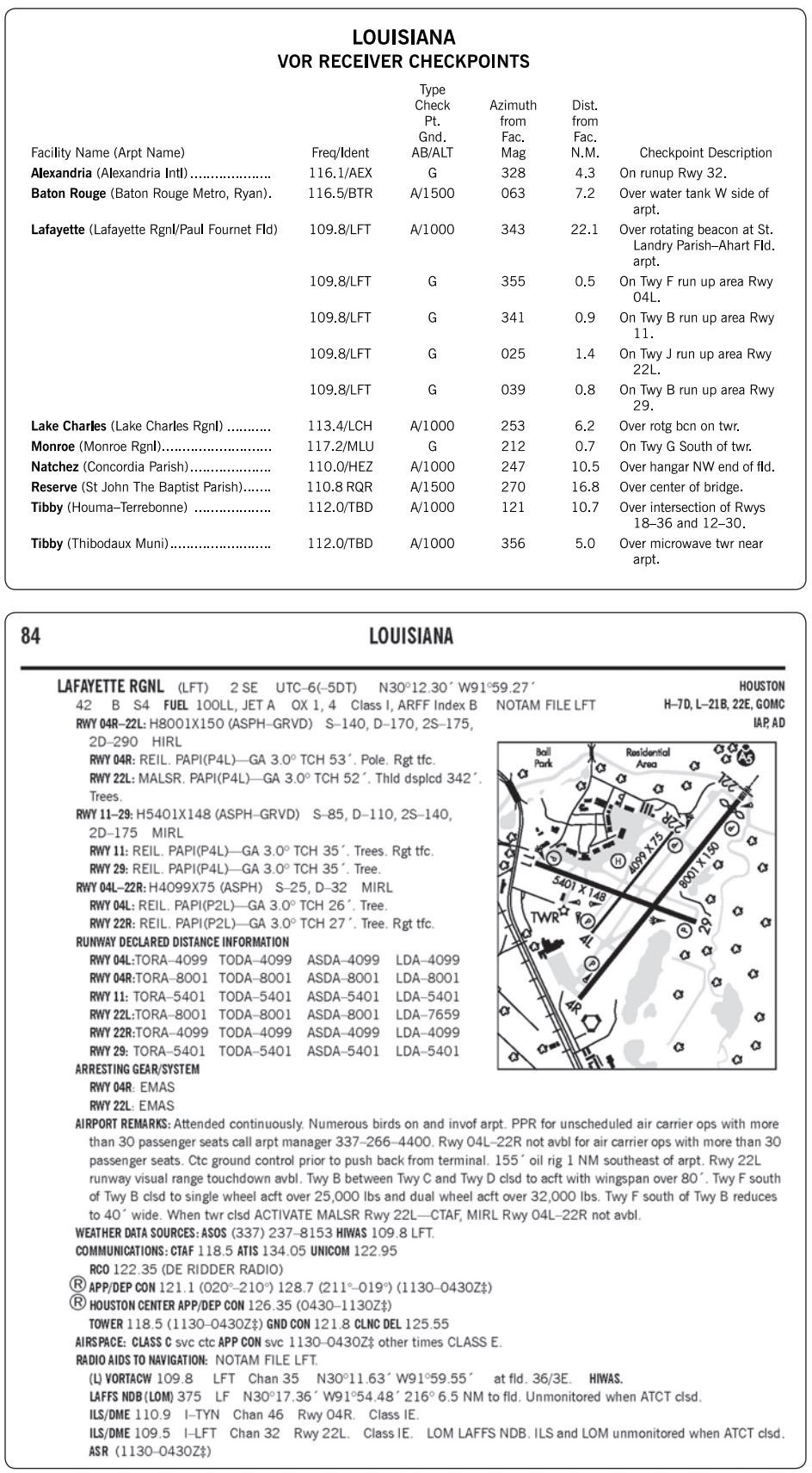
 CorrectIncorrect
 -
Question 48 of 61
48. Question
Refer to figure 65 below. Which point would be the appropriate VOR COP on V552 from the LFT to the TBD VORTACs?
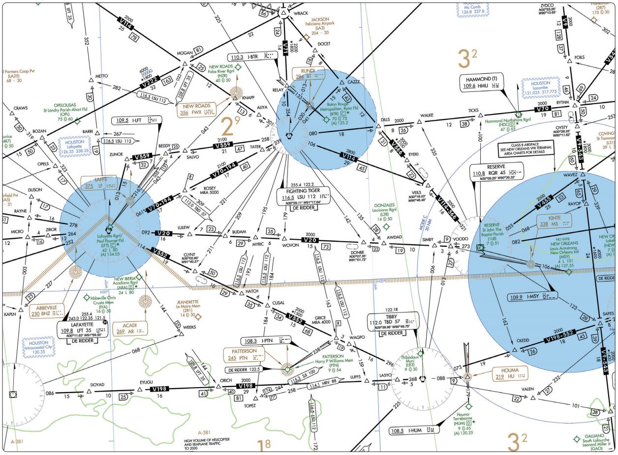 CorrectIncorrect
 -
Question 49 of 61
49. Question
CorrectIncorrect -
Question 50 of 61
50. Question
Refer to figure 65 and figure 67 below. What is the significance of the symbol at GRICE intersection?
 CorrectIncorrect
 -
Question 51 of 61
51. Question
Refer to figure 87 below. Where is the VOR COP when flying east on V306 from Daisetta to Lake Charles?
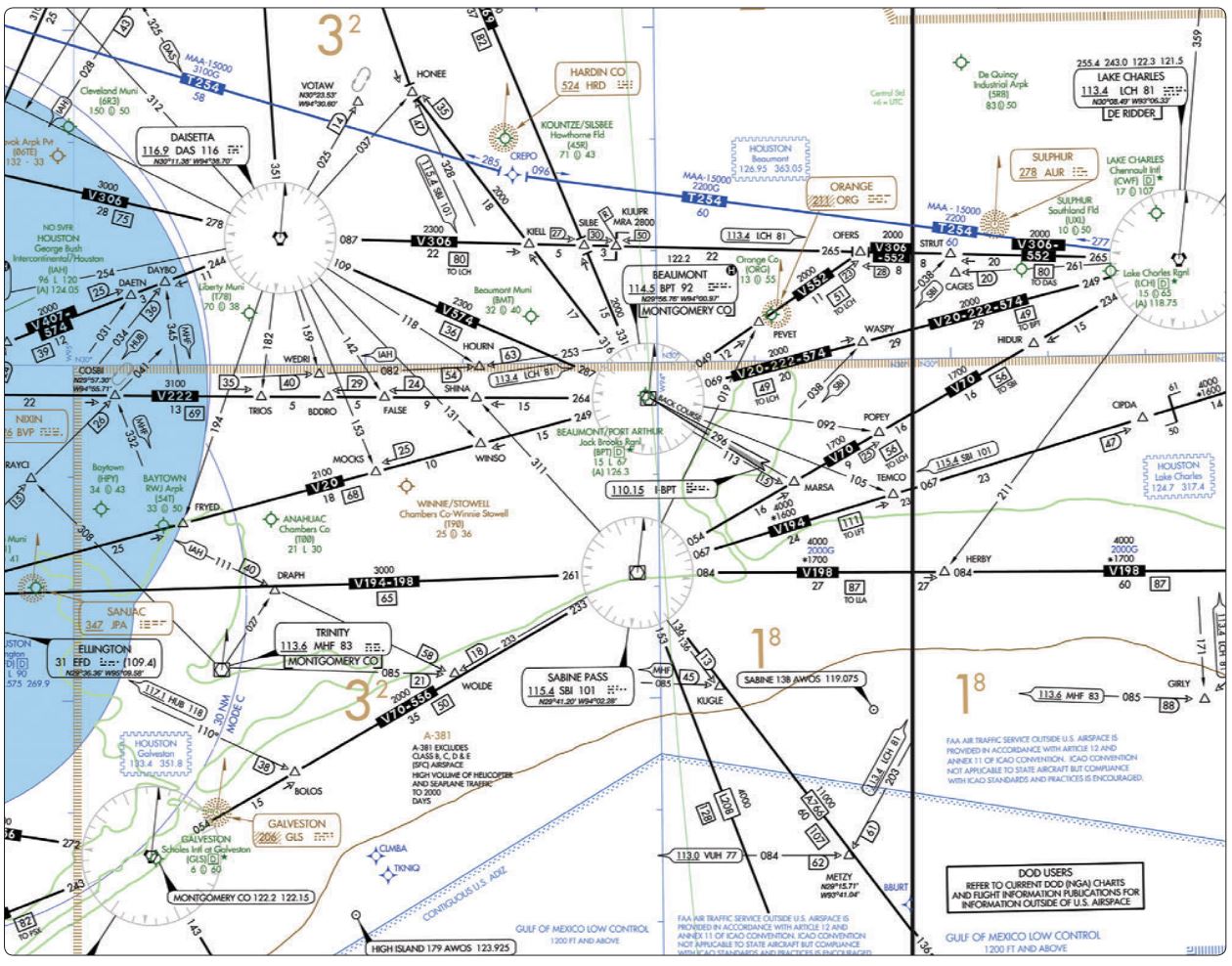 CorrectIncorrect
 -
Question 52 of 61
52. Question
Refer to figure 87 below. What is indicated by the localizer course symbol at Jack Brooks Regional Airport?
CorrectIncorrect -
Question 53 of 61
53. Question
Refer to figure 87 below. While holding at the 10 DME fix east of LCH for an ILS approach to RWY 15 at Lake Charles Muni Airport, ATC advises you to expect clearance for the approach at 1015. At 1000 you experience two-way radio communications failure. Which procedure should be followed?
CorrectIncorrect -
Question 54 of 61
54. Question
Refer to figure 87 below. At STRUT intersection headed eastbound, ATC instructs you to hold west on the 10 DME fix west of LCH on V306, standard turns. What entry procedure is
recommended?CorrectIncorrect -
Question 55 of 61
55. Question
Refer to figure 87 below. Which VHF frequencies, other than 121.5, can be used to receive De Ridder FSS in the Lake Charles area?
CorrectIncorrect -
Question 56 of 61
56. Question
Refer to figure 87 and legend 34 below. Where is the VOR changeover point on V20 between Beaumont and Hobby?
 CorrectIncorrect
 -
Question 57 of 61
57. Question
Refer to figure 88 and figure 87 below. What is your position with reference to FALSE intersection (V222) if your VOR receivers indicate as shown?
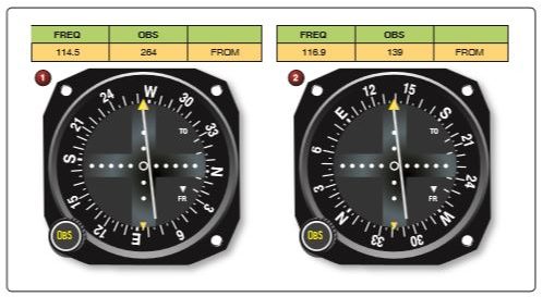 CorrectIncorrect
 -
Question 58 of 61
58. Question
Refer to figure 89 below. When flying from Milford Municipal to Bryce Canyon via V235 and V293, what minimum altitude should you be at when crossing Cedar City VOR?
CorrectIncorrect -
Question 59 of 61
59. Question
Refer to figure 89 below. What VHF frequencies are available for communications with Cedar City FSS
 CorrectIncorrect
 -
Question 60 of 61
60. Question
Refer to figure 89 below. What are the oxygen requirements for an IFR flight northeast bound from Bryce Canyon on V382 at the lowest appropriate altitude in an unpressurized aircraft?
CorrectIncorrect -
Question 61 of 61
61. Question
Refer to figure 89 below What is the ARTCC discrete frequency at the COP on V208 southwest bound from HVE to PGA VOR/DME?
CorrectIncorrect