CFI Aviation Weather
Quiz Summary
0 of 136 questions completed
Questions:
Information
You have already completed the quiz before. Hence you can not start it again.
Quiz is loading…
You must sign in or sign up to start the quiz.
You must first complete the following:
Results
Results
0 of 136 questions answered correctly
Your time:
Time has elapsed
You have reached 0 of 0 point(s), (0)
Earned Point(s): 0 of 0, (0)
0 Essay(s) Pending (Possible Point(s): 0)
Categories
- Not categorized 0%
- 1
- 2
- 3
- 4
- 5
- 6
- 7
- 8
- 9
- 10
- 11
- 12
- 13
- 14
- 15
- 16
- 17
- 18
- 19
- 20
- 21
- 22
- 23
- 24
- 25
- 26
- 27
- 28
- 29
- 30
- 31
- 32
- 33
- 34
- 35
- 36
- 37
- 38
- 39
- 40
- 41
- 42
- 43
- 44
- 45
- 46
- 47
- 48
- 49
- 50
- 51
- 52
- 53
- 54
- 55
- 56
- 57
- 58
- 59
- 60
- 61
- 62
- 63
- 64
- 65
- 66
- 67
- 68
- 69
- 70
- 71
- 72
- 73
- 74
- 75
- 76
- 77
- 78
- 79
- 80
- 81
- 82
- 83
- 84
- 85
- 86
- 87
- 88
- 89
- 90
- 91
- 92
- 93
- 94
- 95
- 96
- 97
- 98
- 99
- 100
- 101
- 102
- 103
- 104
- 105
- 106
- 107
- 108
- 109
- 110
- 111
- 112
- 113
- 114
- 115
- 116
- 117
- 118
- 119
- 120
- 121
- 122
- 123
- 124
- 125
- 126
- 127
- 128
- 129
- 130
- 131
- 132
- 133
- 134
- 135
- 136
- Current
- Review
- Answered
- Incorrect
-
Question 1 of 136
1. Question
Which is the primary driving force of weather on the Earth?
CorrectIncorrect -
Question 2 of 136
2. Question
What causes wind?
CorrectIncorrect -
Question 3 of 136
3. Question
Winds at 5,000 feet AGL on a particular flight are southwesterly while most of the surface winds are southerly. This difference in directions primarily due to
CorrectIncorrect -
Question 4 of 136
4. Question
In what part of the atmosphere does most weather occur?
CorrectIncorrect -
Question 5 of 136
5. Question
The general circulation of air associated with a high-pressure area in the Northern Hemisphere is
CorrectIncorrect -
Question 6 of 136
6. Question
When flying from a high- to a low-pressure area in the Northern Hemisphere, the wind direction and velocity will be from the
CorrectIncorrect -
Question 7 of 136
7. Question
The windflow around a low pressure is
CorrectIncorrect -
Question 8 of 136
8. Question
In the Northern Hemisphere, a pilot making a long distance flight from east to west would most likely find favorable winds associated with high- and low pressure systems by flying to the
CorrectIncorrect -
Question 9 of 136
9. Question
Which is true regarding the development of convective circulation?
CorrectIncorrect -
Question 10 of 136
10. Question
Convective circulation patterns associated with sea breezes are caused by
CorrectIncorrect -
Question 11 of 136
11. Question
Select the true statement concerning thermals
CorrectIncorrect -
Question 12 of 136
12. Question
Which statement is true regarding high- or low pressure systems?
CorrectIncorrect -
Question 13 of 136
13. Question
The ratio of the existing water vapor in the air, as compared to the maximum amount that could exist at a given temperature, is called
CorrectIncorrect -
Question 14 of 136
14. Question
Which is an operational consideration regarding actual air temperature and dewpoint temperature spread?
CorrectIncorrect -
Question 15 of 136
15. Question
One condition necessary for the formation of fog is
CorrectIncorrect -
Question 16 of 136
16. Question
Fog associated with a warm front is a result of saturation due to
CorrectIncorrect -
Question 17 of 136
17. Question
You may anticipate fog when the temperature dew point spread is
CorrectIncorrect -
Question 18 of 136
18. Question
What is the process by which ice can form on a surface directly from water vapor on a cold, clear night?
CorrectIncorrect -
Question 19 of 136
19. Question
Radiation fog is most likely to occur under what conditions?
CorrectIncorrect -
Question 20 of 136
20. Question
Advection fog is formed as a result of
CorrectIncorrect -
Question 21 of 136
21. Question
With respect to advection fog, which statement is true?
CorrectIncorrect -
Question 22 of 136
22. Question
Which in-flight hazard is most commonly associated with warm fronts
CorrectIncorrect -
Question 23 of 136
23. Question
When warm air moves over a cold lake, what weather phenomenon is likely to occur on the leeward side of the lake?
CorrectIncorrect -
Question 24 of 136
24. Question
What are the standard temperature and pressure values for mean sea level?
CorrectIncorrect -
Question 25 of 136
25. Question
If the air temperature is +6°C at an elevation of 700 feet and a standard (average) temperature lapse rate exists, what will be the approximate freezing level?
CorrectIncorrect -
Question 26 of 136
26. Question
freezing level?
CorrectIncorrect -
Question 27 of 136
27. Question
The most frequent type of ground- or surface based temperature inversion is that produced by
CorrectIncorrect -
Question 28 of 136
28. Question
Which weather conditions should be expected beneath a low-level temperature inversion layer when the relative humidity is high?
CorrectIncorrect -
Question 29 of 136
29. Question
At approximately what altitude above the surface would you expect the base of cumuliform clouds if the surface air temperature is 77°F and the dewpoint is 53°F?
CorrectIncorrect -
Question 30 of 136
30. Question
At approximately what altitude above the surface would you expect the base of cumuliform clouds if the surface air temperature is 33°C and the dewpoint is 15°C dewpoint is 15°C?
CorrectIncorrect -
Question 31 of 136
31. Question
The average lapse rate in the troposphere is
CorrectIncorrect -
Question 32 of 136
32. Question
From which measurement of the atmosphere can stability be determined?
CorrectIncorrect -
Question 33 of 136
33. Question
What is a characteristic of stable air?
CorrectIncorrect -
Question 34 of 136
34. Question
What is a typical characteristic of a stable air mass?
CorrectIncorrect -
Question 35 of 136
35. Question
A moist, warm air mass that is being cooled from below is characterized, in part, by
CorrectIncorrect -
Question 36 of 136
36. Question
A moist, cold air mass that is being warmed from below is characterized, in part, by
CorrectIncorrect -
Question 37 of 136
37. Question
Cool air moving over a warm surface is generally characterized by
CorrectIncorrect -
Question 38 of 136
38. Question
Consider the following air mass characteristics:
- Cumuliform clouds.
- Stable lapse rate.
- Unstable lapse rate.
- Stratiform clouds and fog.
- Smooth air (above the friction level) and poor visibility.
- Turbulence up to about 10,000 feet and good visibility except in areas of precipitation.
A moist air mass, which is colder than the surface over which it passes, frequently has which of the above characteristics?
CorrectIncorrect -
Question 39 of 136
39. Question
The weather condition normally associated with unstable air is
CorrectIncorrect -
Question 40 of 136
40. Question
A moist, unstable air mass is characterized by
CorrectIncorrect -
Question 41 of 136
41. Question
What type weather can one expect from moist, unstable air and very warm surface temperature?
CorrectIncorrect -
Question 42 of 136
42. Question
If clouds form as a result of very stable, moist air being forced to ascend a mountain slope, the clouds will be
CorrectIncorrect -
Question 43 of 136
43. Question
The formation of either predominantly stratiform or predominantly cumuliform clouds is dependent upon the
CorrectIncorrect -
Question 44 of 136
44. Question
Convective SIGMETs are issued for which weather conditions?
CorrectIncorrect -
Question 45 of 136
45. Question
A surface inversion can
CorrectIncorrect -
Question 46 of 136
46. Question
An increase in temperature with an altitude increase
CorrectIncorrect -
Question 47 of 136
47. Question
Frontal waves normally form on
CorrectIncorrect -
Question 48 of 136
48. Question
If a wave were to form on a stationary front running east and west across the United States, that portion east of the wave would normally
CorrectIncorrect -
Question 49 of 136
49. Question
What type weather is associated with an advancing warm front that has moist, unstable air?
CorrectIncorrect -
Question 50 of 136
50. Question
Which statement is true regarding a cold front occlusion?
CorrectIncorrect -
Question 51 of 136
51. Question
Consider the following statements about mountain waves:
- Mountain waves always develop in a series on the upwind (windward) side of mountain ridges.
- In a mountain wave, the air dips sharply downward immediately to the lee side of a ridge, before rising and falling in a wave motion for a considerable distance downstream.
- If the air is humid and the wave is of large amplitude, lenticular (lens-shaped) clouds mark the wave’s crest.
- In a typical wave, the greatest amplitude is seldom more than 1,000 feet above the ridge crest elevation.
From the statements above, select those that are true.
CorrectIncorrect -
Question 52 of 136
52. Question
One of the most dangerous features of mountain waves is the turbulent areas in and
CorrectIncorrect -
Question 53 of 136
53. Question
When flying low over hilly terrain, ridges, or mountain ranges, the greatest potential danger from turbulent air currents will usually be encountered on the
CorrectIncorrect -
Question 54 of 136
54. Question
The conditions most favorable to wave formation over mountainous areas are a layer of
CorrectIncorrect -
Question 55 of 136
55. Question
Low-level wind shear, which results in a sudden change of wind direction, may occur
CorrectIncorrect -
Question 56 of 136
56. Question
Which condition could be expected if a strong temperature inversion exists near the surface?
CorrectIncorrect -
Question 57 of 136
57. Question
In reference to clear air turbulence (CAT), areas to be avoided are those where horizontal wind shear exceeds
CorrectIncorrect -
Question 58 of 136
58. Question
What are the minimum requirements for the formation of a thunderstorm?
CorrectIncorrect -
Question 59 of 136
59. Question
Select the true statement pertaining to the life cycle of a thunderstorm.
CorrectIncorrect -
Question 60 of 136
60. Question
What feature is associated with the cumulus stage of a thunderstorm?
CorrectIncorrect -
Question 61 of 136
61. Question
A squall line is usually associated with a
CorrectIncorrect -
Question 62 of 136
62. Question
Which type of cloud is associated with violent turbulence and a tendency toward the production of funnel clouds?
CorrectIncorrect -
Question 63 of 136
63. Question
Tornadoes are most likely to occur with which type of thunderstorms?
CorrectIncorrect -
Question 64 of 136
64. Question
What is the expected duration of an individual microburst?
CorrectIncorrect -
Question 65 of 136
65. Question
Maximum downdrafts in a microburst encounter may be as strong as
CorrectIncorrect -
Question 66 of 136
66. Question
How long do the maximum intensity winds last in an individual microburst?
CorrectIncorrect -
Question 67 of 136
67. Question
Which situation would most likely result in freezing rain?
CorrectIncorrect -
Question 68 of 136
68. Question
Consider the following statements regarding hail as an in-flight hazard and select those which are correct.
- There is a correlation between the visual appearance of thunderstorms and the amount of hail within them.
- Large hail is most commonly found in thunderstorms which have strong updrafts and large liquid water content.
- Hail may be found at any level within a thunderstorm but not in the clear air outside of the storm cloud.
- Hail is usually produced during the mature stage of the thunderstorm’s lifespan.
- Hailstones may be thrown upward and outward from a storm cloud for several miles.
The true statements are:
CorrectIncorrect -
Question 69 of 136
69. Question
Which statement is true concerning the in-flight hazard of hail?
CorrectIncorrect -
Question 70 of 136
70. Question
Hail, an in-flight hazard, is most likely to be associated with
CorrectIncorrect -
Question 71 of 136
71. Question
Hail will most likely be encountered
CorrectIncorrect -
Question 72 of 136
72. Question
Which precipitation type usually indicates freezing rain at higher altitudes?
CorrectIncorrect -
Question 73 of 136
73. Question
The most rapid accumulation of clear ice on an aircraft in flight may occur with temperatures between 0°C to – 15°C in
CorrectIncorrect -
Question 74 of 136
74. Question
Which is an operational consideration regarding aircraft structural icing?
CorrectIncorrect -
Question 75 of 136
75. Question
A generally recommended practice for autopilot usage during cruise flight in icing conditions is
CorrectIncorrect -
Question 76 of 136
76. Question
The height of the bases of the middle clouds in the middle latitudes ranges from
CorrectIncorrect -
Question 77 of 136
77. Question
Which middle level clouds are characterized by rain, snow, or ice pellets posing a serious icing problem if temperatures are near or below freezing?
CorrectIncorrect -
Question 78 of 136
78. Question
One of the best visual indications of a thermal is a
CorrectIncorrect -
Question 79 of 136
79. Question
Streamers of precipitation trailing beneath clouds but evaporating before reaching the ground are known as
CorrectIncorrect -
Question 80 of 136
80. Question
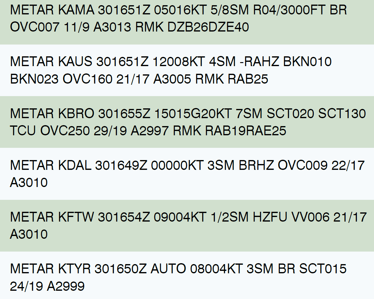
Refer to the diagram below. Which station is reporting the lowest ceiling?
 CorrectIncorrect
 -
Question 81 of 136
81. Question
Refer to the diagram below. Which station is reporting the wind as calm?
 CorrectIncorrect
 -
Question 82 of 136
82. Question
Refer to the diagram below. In the report for KBRO, what is the reported ceiling?
 CorrectIncorrect
 -
Question 83 of 136
83. Question
Refer to the diagram below. The temperature/dewpoint spread at KAUS is
 CorrectIncorrect
 -
Question 84 of 136
84. Question
Refer to the diagram below. What is the reported duration of the rain at the time of the observation at KAUS?
 CorrectIncorrect
 -
Question 85 of 136
85. Question
Refer to the diagram below. What is the reported duration of the rain at the time of the observation at KBRO?
 CorrectIncorrect
 -
Question 86 of 136
86. Question
GIVEN: METAR KOUN 1513552 AUTO 22010KT 10SM CLR BLO 120 13/10 A2993 RMK A02 $. The ASOS report indicates that the location is
CorrectIncorrect -
Question 87 of 136
87. Question
Consider the following statements regarding an Aviation Routine Weather Report (METAR).
- A vertical visibility entry does not constitute a ceiling.
- Fog (FG) can be reported only if the visibility is less than 5/8 mile.
- The ceiling layer will be designated by a “C.”
- Mist (BR) can be reported only if the visibility is 5/8 mile up to six miles.
- Temperatures reported below zero will be prefixed with a”-.”
- There is no provision to report partial obscurations.
Select the true statements.
CorrectIncorrect -
Question 88 of 136
88. Question
Which statement is true concerning ASOS/AWOS weather reporting systems?
CorrectIncorrect -
Question 89 of 136
89. Question
GIVEN: METAR KPNC 131215 AUTO 33025KT 1/2SM OVC005 OO/M03 A2990 RMK A02 SLPNO
This ASOS report indicates that the
CorrectIncorrect -
Question 90 of 136
90. Question
The base and tops of the overcast layer reported by a pilot are
 CorrectIncorrect
 -
Question 91 of 136
91. Question
Refer to the diagram below. The wind and temperature at 12,000 feet MSL as reported by a pilot are
 CorrectIncorrect
 -
Question 92 of 136
92. Question
Refer to the diagram below. The intensity of the turbulence reported at a specific altitude is
 CorrectIncorrect
 -
Question 93 of 136
93. Question
Refer to the diagram below. If the terrain elevation is 1,295 feet MSL, what is the height above ground level of the base of the ceiling?
 CorrectIncorrect
 -
Question 94 of 136
94. Question
Consider the following statements regarding a Pilot Weather Report (PIREP).
- A vertical visibility entry does not constitute a ceiling.
- Fog (FG) can be reported only if the visibility is less than 5/8 mile.
- The ceiling layer will be designated by a “C.”
- Mist (BR) can be reported only if the visibility is greater than or equal to 5/8 statute mile.
- Temperatures reported below zero will be prefixed with a “- .”
- There is no provision to report partial obscurations.
Select the true statements.
CorrectIncorrect -
Question 95 of 136
95. Question
Interpret the following radar weather report:
LIT 1133 AREA 4TRW 22/100 88/170 196/180 220/115 C2425 MT 310 AT 162/110
CorrectIncorrect -
Question 96 of 136
96. Question
Which statement is true concerning this radar weather report for OKC?
OKC 1934 LN 8TRW / 86/ 40 164/60 199/115 15W 2425MT 570 AT 159/65 2 INCH HAIL RPRTD THIS ECHO.
CorrectIncorrect -
Question 97 of 136
97. Question
The intensity trend of a front (as of chart time) is best determined by referring to a
CorrectIncorrect -
Question 98 of 136
98. Question
On a Surface Analysis Weather Chart, isobars are usually spaced at intervals of
CorrectIncorrect -
Question 99 of 136
99. Question
The strength and position of a front (as of chart time) is best determined by referring to a
CorrectIncorrect -
Question 100 of 136
100. Question
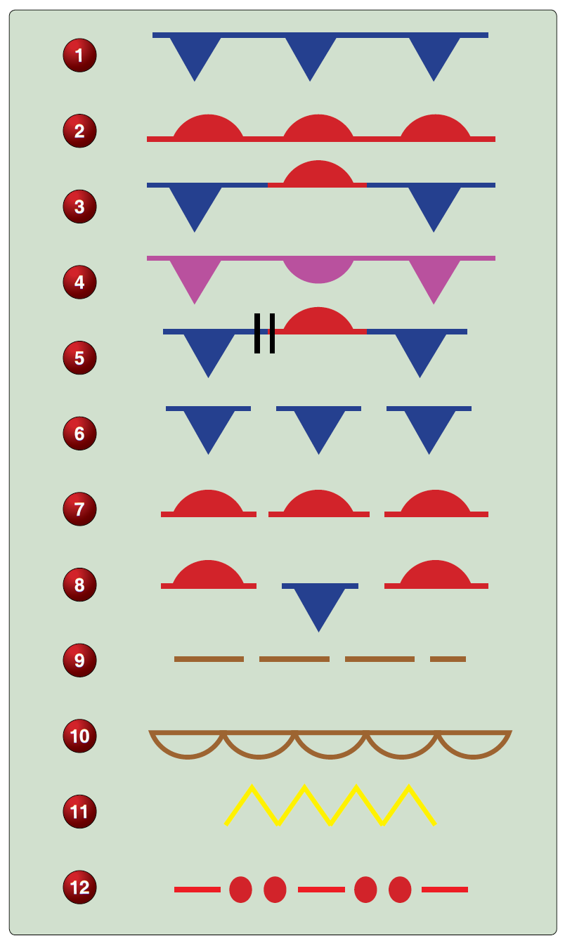
Refer to the diagram below. Which symbol is used when there is a change in the front type?
 CorrectIncorrect
 -
Question 101 of 136
101. Question
Refer to the diagram below. Refer to illustration 12. What does this symbol mean on a Surface Analysis Weather Chart?
 CorrectIncorrect
 -
Question 102 of 136
102. Question
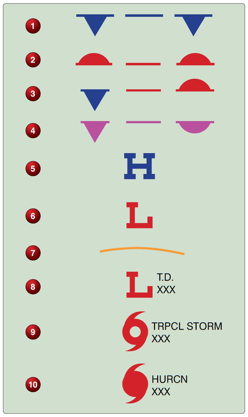
Refer to the diagram below. What type of front is show in illustration 4?
 CorrectIncorrect
 -
Question 103 of 136
103. Question
Refer to the diagram below. Which illustration indicates a tropical wave?
 CorrectIncorrect
 -
Question 104 of 136
104. Question
Refer to the diagram below. Which symbol used on a Surface Analysis Weather Chart represents a dissipating warm front?
 CorrectIncorrect
 -
Question 105 of 136
105. Question
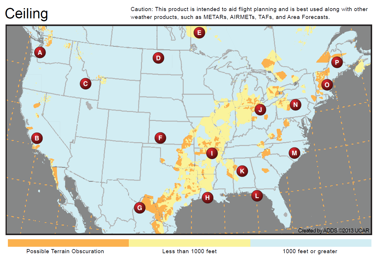
Refer to the diagram below. After determining your route of flight will take you through area L, you will most likely find which of the following weather conditions?
 CorrectIncorrect
 -
Question 106 of 136
106. Question
Refer to the diagram below. After determining your destination is in the vicinity of area J, you should review which of the following weather products next?
 CorrectIncorrect
 -
Question 107 of 136
107. Question
Refer to the diagram below. After determining your route of flight will take you through area E, you will most likely find which of the following weather conditions?
 CorrectIncorrect
 -
Question 108 of 136
108. Question
When using a Constant Pressure Analysis Chart for planning a flight at 10,000 feet MSL, a pilot should refer to the
CorrectIncorrect -
Question 109 of 136
109. Question
From which of the following can the observed temperature, wind, and temperature/dewpoint spread be determined at specified flight levels?
CorrectIncorrect -
Question 110 of 136
110. Question
Refer to the diagram below. For a flight between Denver, CO, and Las Vegas, NV, you should expect the following turbulent conditions:
 CorrectIncorrect
 -
Question 111 of 136
111. Question
Refer to the diagram below. After analyzing your flight path through northwestern Illinois and eastern Iowa, you should continue your flight planning by examining
 CorrectIncorrect
 -
Question 112 of 136
112. Question
Which weather chart depicts the conditions forecast to exist at a specific time in the future?
CorrectIncorrect -
Question 113 of 136
113. Question
Refer to the diagram below. What do the blue colored semi-circular polygons located southeast of each cell indicate?
 CorrectIncorrect
 -
Question 114 of 136
114. Question
Refer to the diagram below. At what speed is the most southern hazard field moving?
 CorrectIncorrect
 -
Question 115 of 136
115. Question
Refer to the diagram below. What direction are the hazard fields moving?
 CorrectIncorrect
 -
Question 116 of 136
116. Question
Refer to the diagram below. What wind is forecast for STL at 9,000 feet?
 CorrectIncorrect
 -
Question 117 of 136
117. Question
Refer to the diagram below. Determine the wind and temperature aloft forecast for DEN at 9,000 feet
 CorrectIncorrect
 -
Question 118 of 136
118. Question
Refer to the diagram below. Determine the wind and temperature aloft forecast for MKC at 6,000 feet
 CorrectIncorrect
 -
Question 119 of 136
119. Question
Which primary source should be used to obtain forecast weather information at your destination for the planned ETA?
CorrectIncorrect -
Question 120 of 136
120. Question
Refer to the diagram below. In the TAF for KMCO, what does “SHRA” stand for?
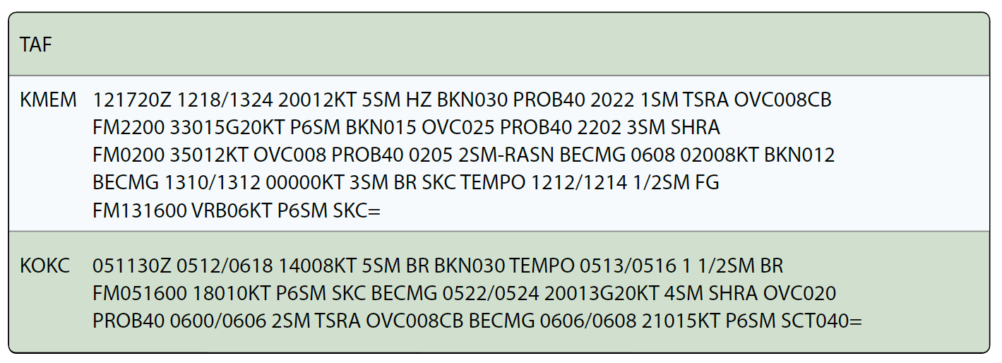
KMCO 021136Z 0212/0312 22005KT P6SM VCSH FEW026 FEW045 SCT180 TEMPO 0212/0214 3SM SHRA BKN020 OVC040 FM021400 27009KT P6SM VCTS SCT020CB BKN035 OVC050 TEMPO 0214/0217 2SM TSRA BKN015CBOVC030 FM021800 34009KT P6SM SCT025 BKN060 FM02210004010KT P6SM SCT040 BKN080 FM030000 09008KT P6SM SCT040 BKN120
 CorrectIncorrect
 -
Question 121 of 136
121. Question
Refer to the diagram below. What is the valid period for the TAF for KMEM?
 CorrectIncorrect
 -
Question 122 of 136
122. Question
Refer to the diagram below. In between 1000Z and 120oz the visibility at KMEM is forecast to be
 CorrectIncorrect
 -
Question 123 of 136
123. Question
Refer to the diagram below. In the TAF from KOKC, the clear sky becomes
 CorrectIncorrect
 -
Question 124 of 136
124. Question
Vertical visibility is shown on Terminal Aerodrome Forecasts (TAF) reports when the sky is
CorrectIncorrect -
Question 125 of 136
125. Question
When the visibility is greater than 6 SM on a TAF it is expressed as
CorrectIncorrect -
Question 126 of 136
126. Question
What is the wind shear forecast in the following TAF?
TAF
KCVG 231051Z 231212 12012KT 4SM – RA BR OVC008
WS005/27050KT TEMPO 1719 1/2SM – RA FG FM1930 09012KT 1SM- DZ BR W003 BECMG
2021 5SM HZ=CorrectIncorrect -
Question 127 of 136
127. Question
Refer to the diagram below. The bottom panel on this Convective Outlook Chart indicates
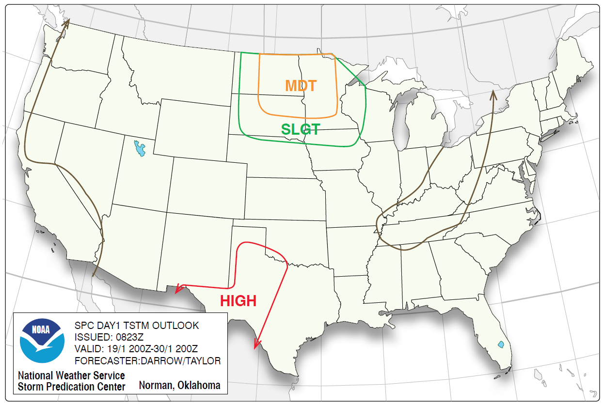
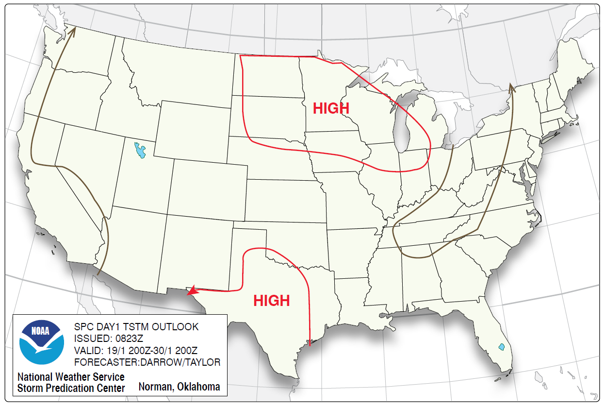 CorrectIncorrect
 -
Question 128 of 136
128. Question
Refer to the diagram below. What percent coverage of severe thunderstorms is forecast to occur in the area of moderate risk in the north-central United States?
|
 CorrectIncorrect
 -
Question 129 of 136
129. Question
Refer to the diagram below. Regarding Convective Outlook Charts, when well-organized severe thunderstorms are expected, but in small numbers and/or low coverage, the risk is referred to as

 CorrectIncorrect
 -
Question 130 of 136
130. Question
If an area on a Convective Outlook Chart is labeled APCHG, this indicates
CorrectIncorrect -
Question 131 of 136
131. Question
To determine the freezing level and areas of probable icing aloft, you should refer to
CorrectIncorrect -
Question 132 of 136
132. Question
What information is contained in a CONVECTIVE SIGMET in the conterminous United States?
CorrectIncorrect -
Question 133 of 136
133. Question
What information would be covered in an
CorrectIncorrect -
Question 134 of 136
134. Question
Which in-flight advisory would contain information on severe icing?
CorrectIncorrect -
Question 135 of 136
135. Question
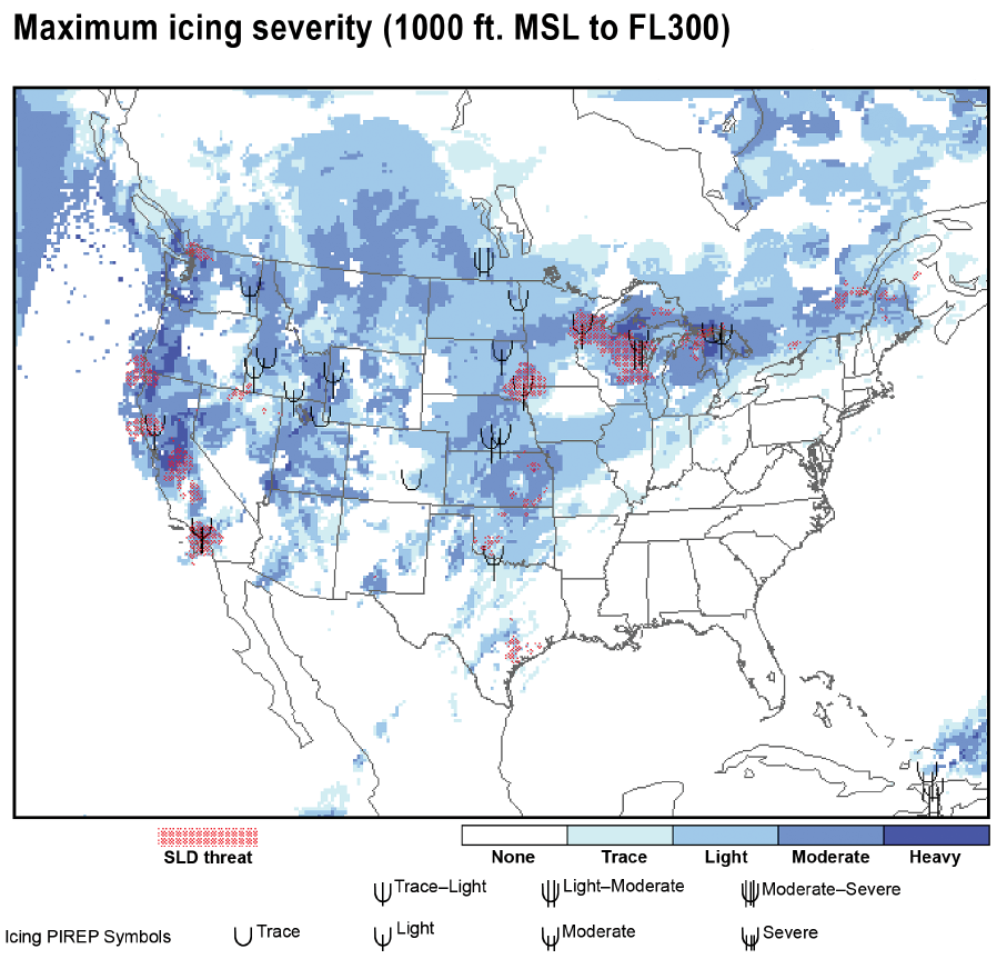
Refer to the diagram below. For a flight between San Francisco, CA, and Seattle, WA, you should expect icing to accumulate to 1/4 inch thickness within:
 CorrectIncorrect
 -
Question 136 of 136
136. Question
Refer to the diagram below. After identifying areas of potential icing, you should review which of the following weather products?
 CorrectIncorrect