Remote Pilot Chapter 2
Quiz Summary
0 of 80 questions completed
Questions:
Information
You have already completed the quiz before. Hence you can not start it again.
Quiz is loading...
You must sign in or sign up to start the quiz.
You must first complete the following:
Results
Results
0 of 80 questions answered correctly
Your time:
Time has elapsed
You have reached 0 of 0 point(s), (0)
Earned Point(s): 0 of 0, (0)
0 Essay(s) Pending (Possible Point(s): 0)
Categories
- Not categorized 0%
- 1
- 2
- 3
- 4
- 5
- 6
- 7
- 8
- 9
- 10
- 11
- 12
- 13
- 14
- 15
- 16
- 17
- 18
- 19
- 20
- 21
- 22
- 23
- 24
- 25
- 26
- 27
- 28
- 29
- 30
- 31
- 32
- 33
- 34
- 35
- 36
- 37
- 38
- 39
- 40
- 41
- 42
- 43
- 44
- 45
- 46
- 47
- 48
- 49
- 50
- 51
- 52
- 53
- 54
- 55
- 56
- 57
- 58
- 59
- 60
- 61
- 62
- 63
- 64
- 65
- 66
- 67
- 68
- 69
- 70
- 71
- 72
- 73
- 74
- 75
- 76
- 77
- 78
- 79
- 80
- Current
- Review
- Answered
- Incorrect
-
Question 1 of 80
1. Question
The most comprehensive information on a given airport is provided
CorrectIncorrect -
Question 2 of 80
2. Question
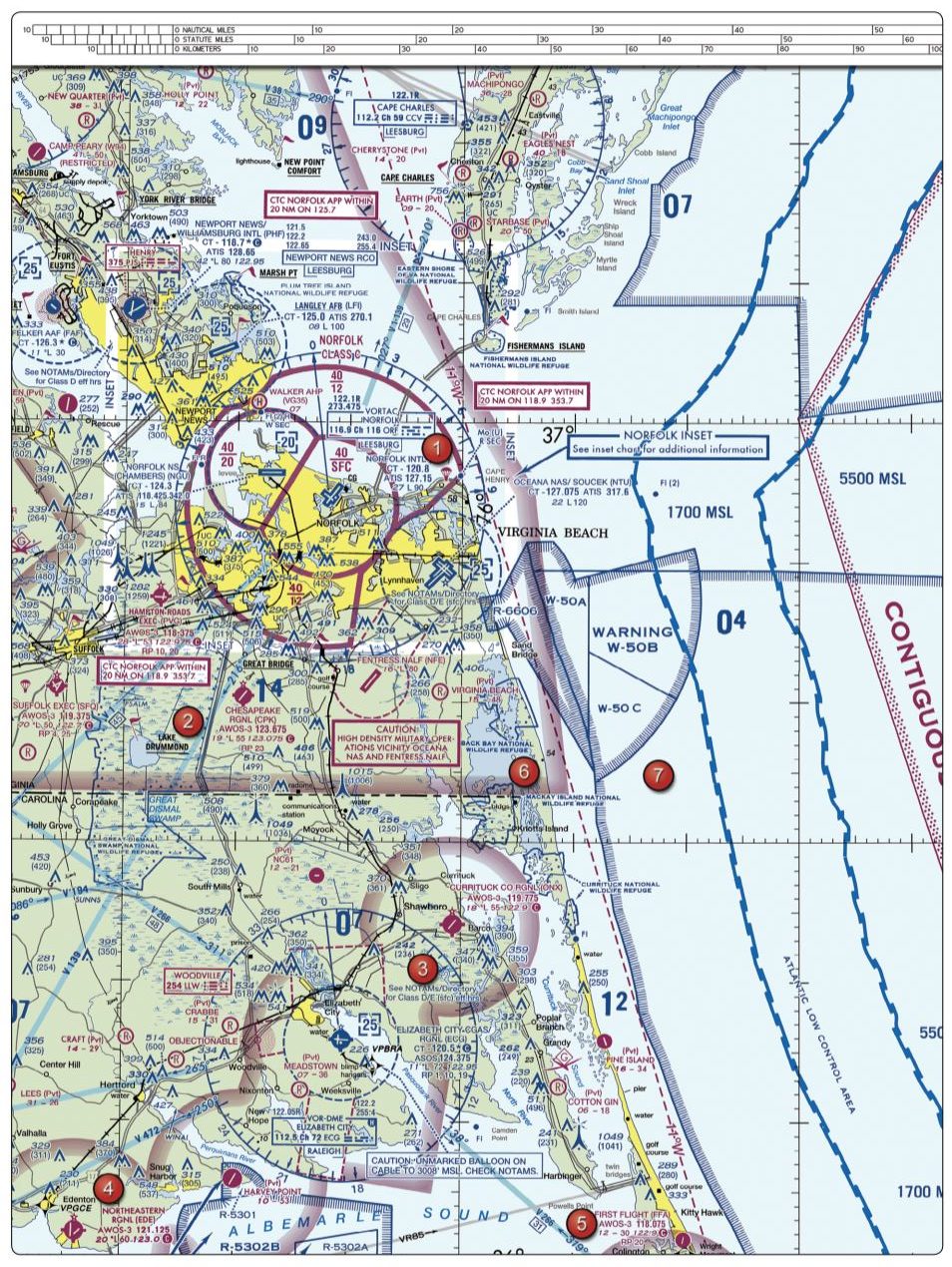
Refer to figure 20, area 5 below. How would a remote PIC "CHECK NOTAMS" as noted in the CAUTION box regarding the unmarked balloon?
 CorrectIncorrect
 -
Question 3 of 80
3. Question
An FDC NOTAM will typically contain information
CorrectIncorrect -
Question 4 of 80
4. Question
What information is contained in the Notices to Airman Publication (NTAP)?
CorrectIncorrect -
Question 5 of 80
5. Question
Flight Data Center (FDC) NOTAMS are issued by the National Flight Data Center and contain regulatory information, such as
CorrectIncorrect -
Question 6 of 80
6. Question
Time-critical information on airports and changes that affect the national airspace system are provided by
CorrectIncorrect -
Question 7 of 80
7. Question
One of the purposes for issuing a temporary flight restriction (TFR) is to
CorrectIncorrect -
Question 8 of 80
8. Question
Public figures are protected by
CorrectIncorrect -
Question 9 of 80
9. Question
The FAA publication that provides the aviation community with basic flight information and Air Traffic Control procedures for use in the National Airspace System of the United States is the
CorrectIncorrect -
Question 10 of 80
10. Question
Refer to figure 31 below. Within what airspace is Coeur D'Alene Pappy Boyington Fld located?
 CorrectIncorrect
 -
Question 11 of 80
11. Question
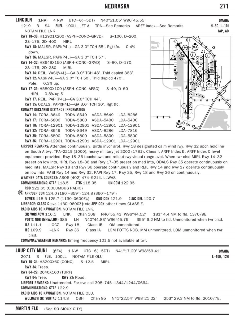
Refer to figure 52 below. What special conditions do remote pilots need to be on the lookout for while operating near Lincoln Airport?
 CorrectIncorrect
 -
Question 12 of 80
12. Question
Checking the NOTAMs confirms the Blue Angels are scheduled to perform at the local airport. When can UAS operations resume relative to this NOTAM?
CorrectIncorrect -
Question 13 of 80
13. Question
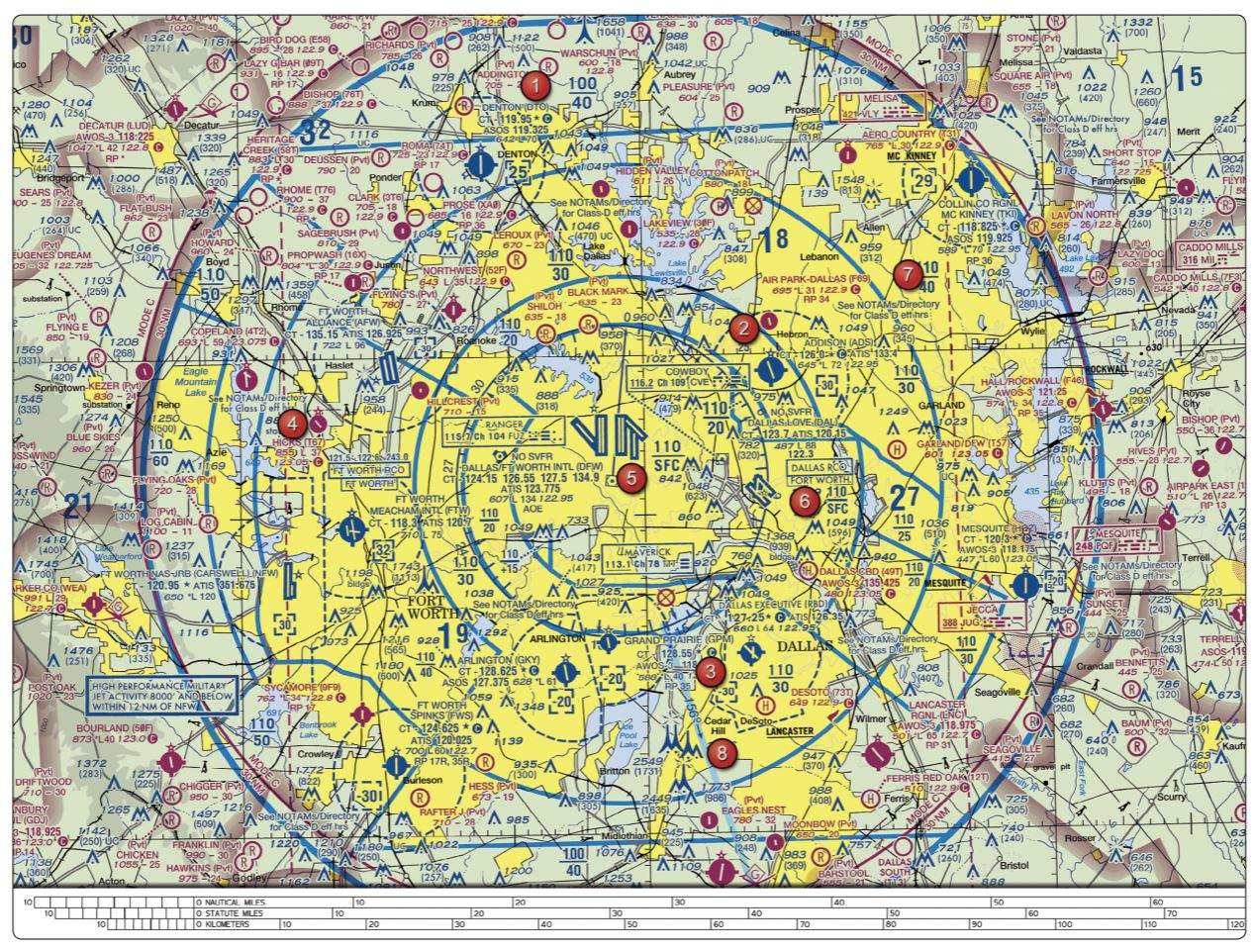
Refer to figure 25, area 4 below. The floor of Class B airspace overlying Hicks Airport (T67) north-northwest of Fort Worth Meacham Field is
 CorrectIncorrect
 -
Question 14 of 80
14. Question
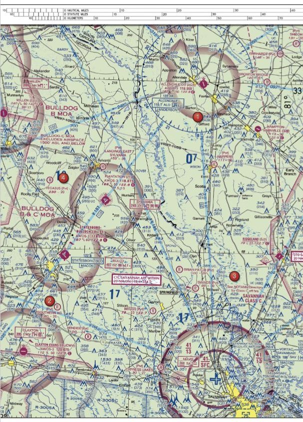
Refer to figure 23, area 3 below. What is the floor of the Savannah Class C airspace at the shelf area (outer circle)?
 CorrectIncorrect
 -
Question 15 of 80
15. Question
According to 14 CFR Part 107, the remote PIC of a small unmanned aircraft planning to operate within Class C airspace
CorrectIncorrect -
Question 16 of 80
16. Question
According to 14 CFR part 107, how may a Remote Pilot in Command (Remote PIC) operate an unmanned aircraft in Class C airspace?
CorrectIncorrect -
Question 17 of 80
17. Question
The lateral dimensions of Class D airspace are based on
CorrectIncorrect -
Question 18 of 80
18. Question
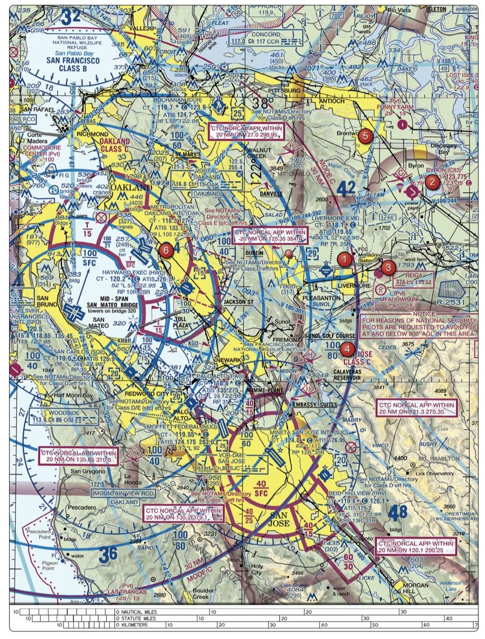
Refer to figure 74, area 6 below. What airspace is Hayward Executive in?
 CorrectIncorrect
 -
Question 19 of 80
19. Question
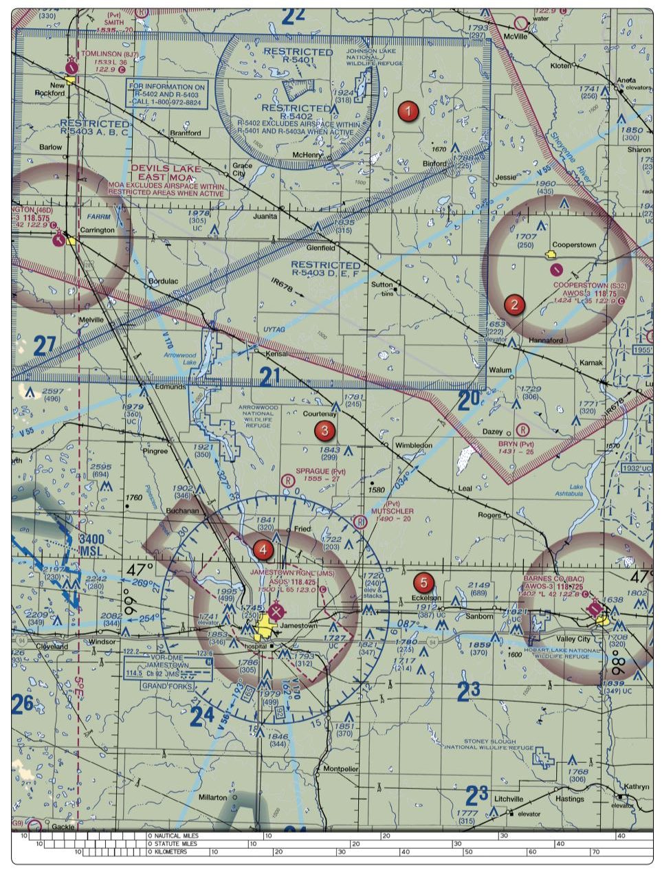
Refer to figure 26 below, area 5. The airspace overlying and within 5 miles of Barnes County Airport is
 CorrectIncorrect
 -
Question 20 of 80
20. Question
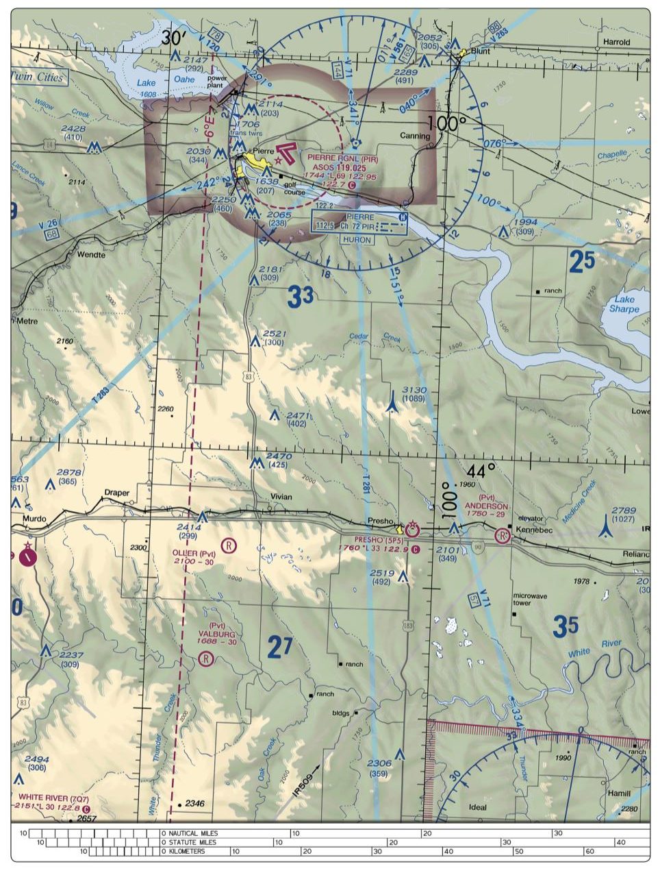
Refer to figure 76 below, What ATC permissions are required to operate near Anderson Airport?
 CorrectIncorrect
 -
Question 21 of 80
21. Question
Refer to figure 78 below. In what airspace is Onawa, IA (K36) located?
 CorrectIncorrect
 -
Question 22 of 80
22. Question
What minimum radio equipment is required for operation within Class C airspace?
CorrectIncorrect -
Question 23 of 80
23. Question
What are the requirements for operating an sUAS in Class C airspace?
CorrectIncorrect -
Question 24 of 80
24. Question
The typical outer radius limits of Class C airspace are
CorrectIncorrect -
Question 25 of 80
25. Question
Refer to figure 25, area 2 below. The airspace directly overlying Addison Airport (ADS) is
 CorrectIncorrect
 -
Question 26 of 80
26. Question
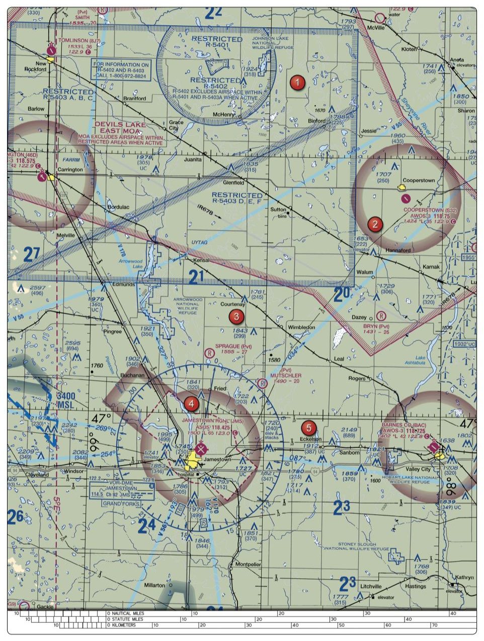
Refer to figure 26, area 1 below. The airspace overlying Tomlinson Airport is
 CorrectIncorrect
 -
Question 27 of 80
27. Question
Refer to figure 78 below, You have been hired to fly your UA to inspect train tracks from the town of Hinton to the town of Winnebago. Will you be able to conduct this flight without contacting ATC?
 CorrectIncorrect
 -
Question 28 of 80
28. Question
Refer to figure 21 below. You have been hired by a farmer to use your small unmanned aircraft to inspect his crops. The area that you are to survey is in the Devil's Lake West MOA, east of area 2. How would you find out if the MOA is active?
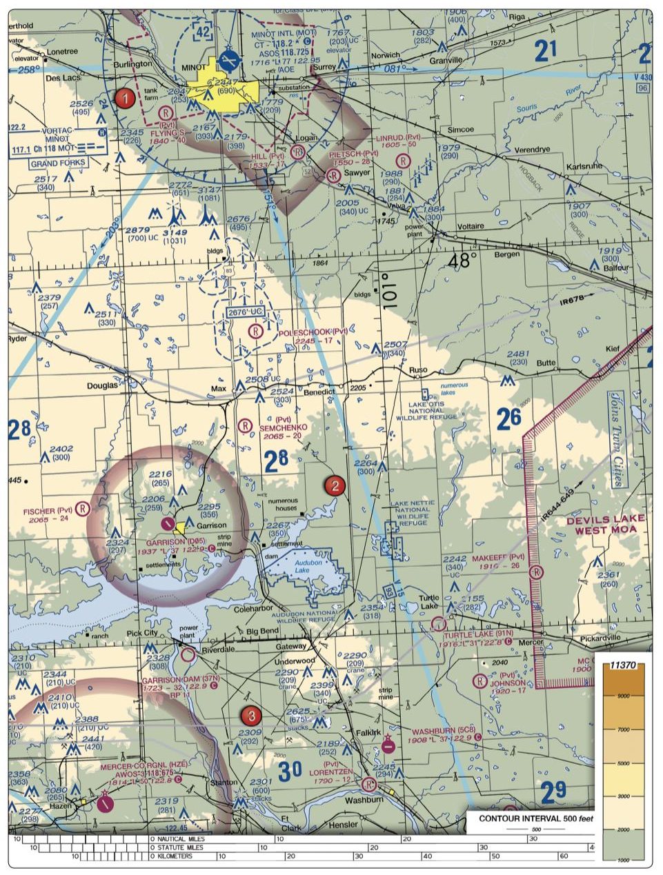 CorrectIncorrect
 -
Question 29 of 80
29. Question
Responsibility for collision avoidance in an alert area rests with
CorrectIncorrect -
Question 30 of 80
30. Question
Refer to figure 22 below, area 2. At Coeur D'Alene, which frequency should be used as a Common Traffic Advisory Frequency (CTAF) to monitor airport traffic?
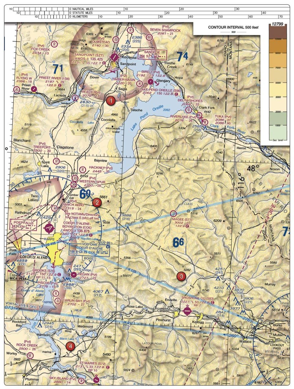 CorrectIncorrect
 -
Question 31 of 80
31. Question
Refer to figure 26 below, area 4. You have been hired to inspect the tower under construction at 46.9N and 98.6W, near Jamestown Regional (JMS). What must you receive prior to flying your unmanned aircraft in this area?
 CorrectIncorrect
 -
Question 32 of 80
32. Question
Refer to figure 59 the diagram below, area 2. The chart shows a gray line with "VR1667, VR1617, VR1638, and VR1668." Could this area present a hazard to the operations of a small unmanned aircraft?
 CorrectIncorrect
 -
Question 33 of 80
33. Question
Refer to figure 24 below, area 5. You are operating an sUAS in the vicinity of Sulphur Springs Airport (SUR) where there is active air traffic. Who has priority and right-of-way within the traffic pattern area?
 CorrectIncorrect
 -
Question 34 of 80
34. Question
Where can you find information about operating in an MOA along your planned route of flight?
CorrectIncorrect -
Question 35 of 80
35. Question
Refer to figure 71 below, area 6. Sky Way Airport is
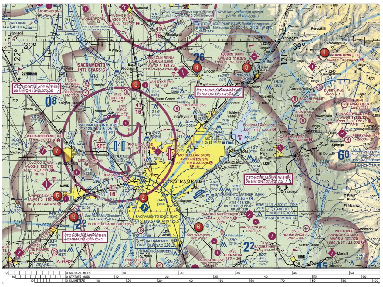 CorrectIncorrect
 -
Question 36 of 80
36. Question
Refer to figure 71 below, area 1. The floor of the Class E airspace above Georgetown Airport (E36) is at
 CorrectIncorrect
 -
Question 37 of 80
37. Question
Refer to figure 75 below. The airspace surrounding the Gila Bend AF AUX Airport (GXF), area 6, is classified as Class
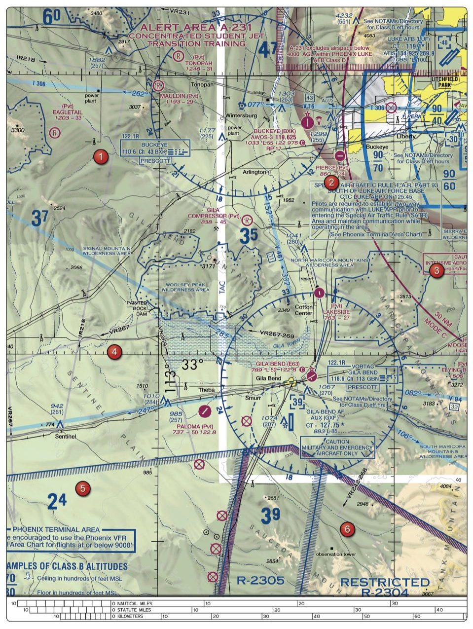 CorrectIncorrect
 -
Question 38 of 80
38. Question
Under what condition, if any, may remote pilots fly through a restricted area?
CorrectIncorrect -
Question 39 of 80
39. Question
Refer to figure 75 below, area 6. Where can you find additional information about "R-2305"?
 CorrectIncorrect
 -
Question 40 of 80
40. Question
Refer to figure 26 below. What does the line of latitude at area 4 measure?
 CorrectIncorrect
 -
Question 41 of 80
41. Question
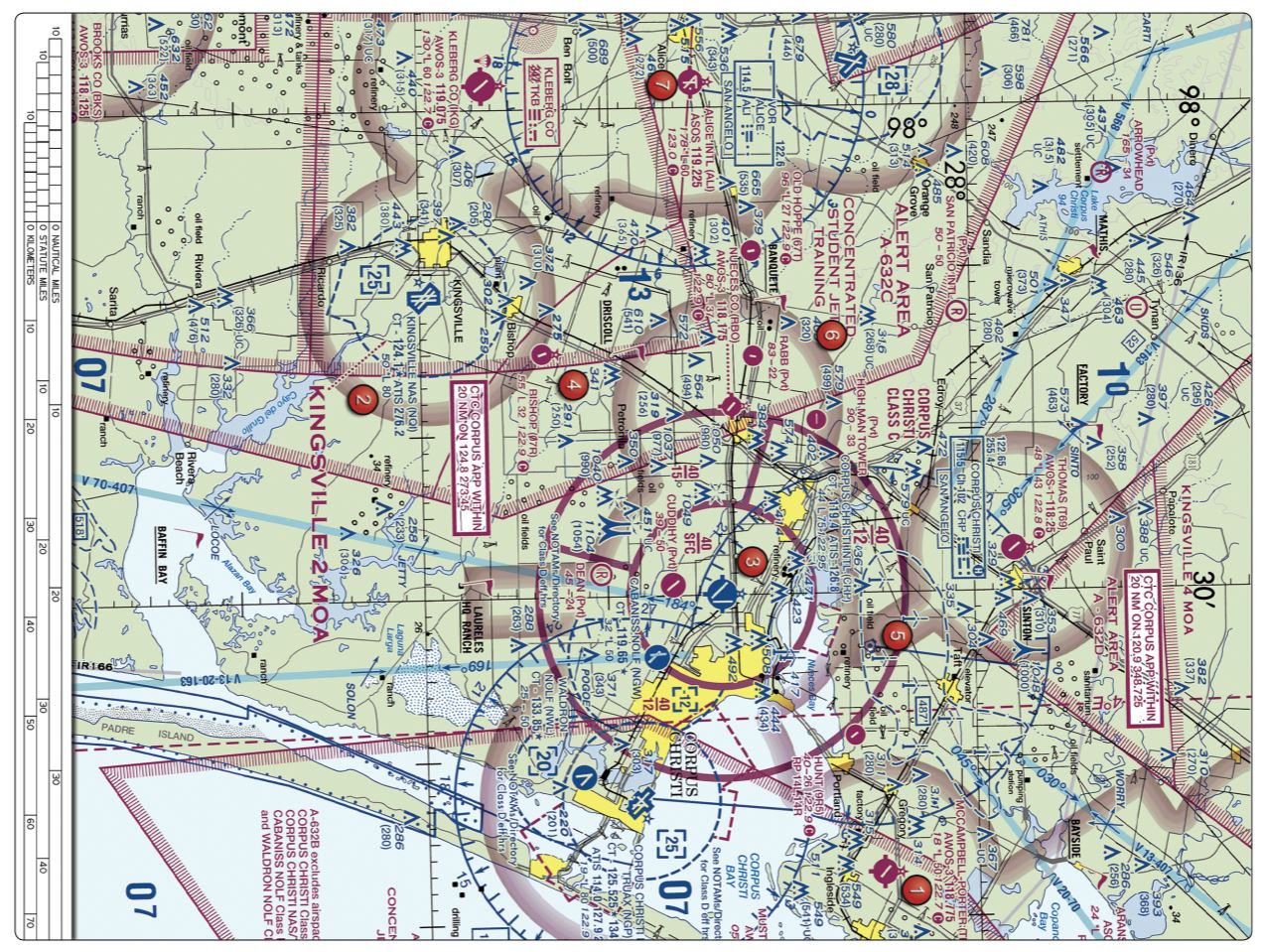
Refer to figure 69 below. What does the line of longitude at area 7 measure?
 CorrectIncorrect
 -
Question 42 of 80
42. Question
Which statement about longitude and latitude is true?
CorrectIncorrect -
Question 43 of 80
43. Question
Refer to figure 21 below. What airport is located approximately 47 (degrees) 40 (minutes) N latitude and 101 (degrees) 26 (minutes) W longitude?
 CorrectIncorrect
 -
Question 44 of 80
44. Question
Refer to figure 20 below, area 3. With ATC authorization, you are operating your small unmanned aircraft approximately 4 SM southeast of Elizabeth City Regional Airport (ECG). What hazard is indicated to be in that area?
 CorrectIncorrect
 -
Question 45 of 80
45. Question
Refer to figure 20 below, area 2. Why would the small flag at Lake Drummond be important to a remote pilot?
 CorrectIncorrect
 -
Question 46 of 80
46. Question
Which is true concerning the blue and magenta colors used to depict airports on Sectional Aeronautical Charts?
CorrectIncorrect -
Question 47 of 80
47. Question
Refer to figure 23 below, area 3. What is the height of the lighted obstacle approximately 6 nautical miles southwest of Savannah International?
 CorrectIncorrect
 -
Question 48 of 80
48. Question
Refer to figure 23 below, area 3. The top of the group obstruction approximately 11 nautical miles from the Savannah VORTAC on the 009° radial is
 CorrectIncorrect
 -
Question 49 of 80
49. Question
Refer to figure 24 below, area 2. Operating an sUAS, can you vertically clear the obstacle on the southeast side of Winnsboro Airport?
 CorrectIncorrect
 -
Question 50 of 80
50. Question
Refer to figure 26 below, area 1. You have been asked to inspect the tower just north of Binford. What restrictions should the remote PIC be concerned with prior to operating the sUAS?
 CorrectIncorrect
 -
Question 51 of 80
51. Question
Refer to figure 24 below, area 1. How close can the Remote PIC fly their sUAS to the Majors airport (GVT} without having to contact ATC?
 CorrectIncorrect
 -
Question 52 of 80
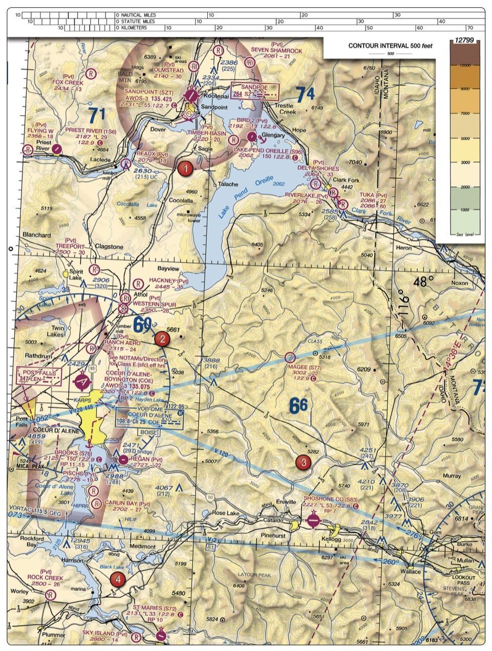
52. Question
Refer to figure 22 below, area 1. You have been contracted to photograph Lake Pend Oreille from a vantage point just east of Cocolalla. You notice there is a hill which should provide a good place to take panoramic photographs. What is the maximum altitude (MSL) you are authorized to fly over the hill?
 CorrectIncorrect
 -
Question 53 of 80
53. Question
Refer to figure 20 below, area 3. What is the latitude and longitude location of the Elizabeth City CGAS RGL (ECG)?
 CorrectIncorrect
 -
Question 54 of 80
54. Question
Refer to figure 20 below, area 3. You need to operate your sUAS in close proximity of the Elizabeth City CGAS RGL (ECG) airport. What frequency should be used to contact ATC?
 CorrectIncorrect
 -
Question 55 of 80
55. Question
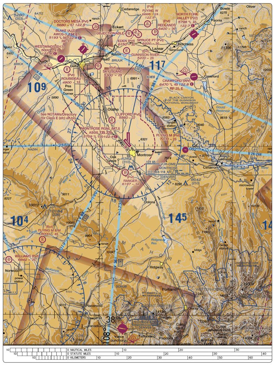
Refer to figure 80 below. What do the blue shaded lines indicate throughout this sectional excerpt?
 CorrectIncorrect
 -
Question 56 of 80
56. Question
The recommended entry position for manned aircraft to enter an airport traffic pattern is
CorrectIncorrect -
Question 57 of 80
57. Question
When a manned aircraft is approaching to land at an airport in Class G airspace without an operating control tower, the pilot will
CorrectIncorrect -
Question 58 of 80
58. Question
Entries into traffic patterns by manned aircraft while descending create specific collision hazards and
CorrectIncorrect -
Question 59 of 80
59. Question
What is required to enter an airport SIDA?
CorrectIncorrect -
Question 60 of 80
60. Question
The numbers 9 and 27 on a runway indicate that the runway is oriented approximately
CorrectIncorrect -
Question 61 of 80
61. Question
Refer to figure 26, area 2 below. While monitoring the Cooperstown CTAF you hear an aircraft announce that they are midfield left downwind to RWY 13. Where would the aircraft be relative to the runway?
 CorrectIncorrect
 -
Question 62 of 80
62. Question
An aircraft announces that they are on short final for runway 9. Where will the aircraft be in relation to the airport?
CorrectIncorrect -
Question 63 of 80
63. Question
You are conducting sUAS operations northeast of a nearby airport. While monitoring the CTAF, an aircraft announces that it is departing runway 36 utilizing a right traffic pattern. Will the aircraft potentially conflict with your operation?
CorrectIncorrect -
Question 64 of 80
64. Question
While operating a sUAS just south of a controlled airport with authorization, ATC notifies you to stay clear of the runway 6 final approach course. What action should you take to comply with this request?
CorrectIncorrect -
Question 65 of 80
65. Question
When turning onto a taxiway from another taxiway, what is the purpose of the taxiway directional sign?
CorrectIncorrect -
Question 66 of 80
66. Question
When approaching holding lines from the side with the continuous lines, the pilot
CorrectIncorrect -
Question 67 of 80
67. Question
What is the purpose of the runway/runway hold position sign?
CorrectIncorrect -
Question 68 of 80
68. Question
What is the purpose for the runway hold position markings on the taxiway?
CorrectIncorrect -
Question 69 of 80
69. Question
Holding position signs have
CorrectIncorrect -
Question 70 of 80
70. Question
What is the purpose of the No Entry sign?
CorrectIncorrect -
Question 71 of 80
71. Question
The ''taxiway ending" marker
CorrectIncorrect -
Question 72 of 80
72. Question
Which publication contains an explanation of airport signs and markings?
CorrectIncorrect -
Question 73 of 80
73. Question
You have received authorization to operate an sUAS at an airport. When flying the sUAS, the ATC tower instructs you to stay clear of all runways. Which situation would indicate that you are complying with this request?
CorrectIncorrect -
Question 74 of 80
74. Question
Most midair collision accidents occur during
CorrectIncorrect -
Question 75 of 80
75. Question
Which technique should a remote pilot use to scan for traffic?
CorrectIncorrect -
Question 76 of 80
76. Question
Guy wires, which support antenna towers, can extend horizontally; therefore, the towers should be avoided horizontally by at least
CorrectIncorrect -
Question 77 of 80
77. Question
What should remote pilots rely on for wire strike avoidance?
CorrectIncorrect -
Question 78 of 80
78. Question
What should a remote pilot do if the sUAS they are operating collides with a bird or wildlife?
CorrectIncorrect -
Question 79 of 80
79. Question
What is the most effective way for a UA pilot to scan for traffic?
CorrectIncorrect -
Question 80 of 80
80. Question
A larger UAS is converging head-on; what should you do?
CorrectIncorrect